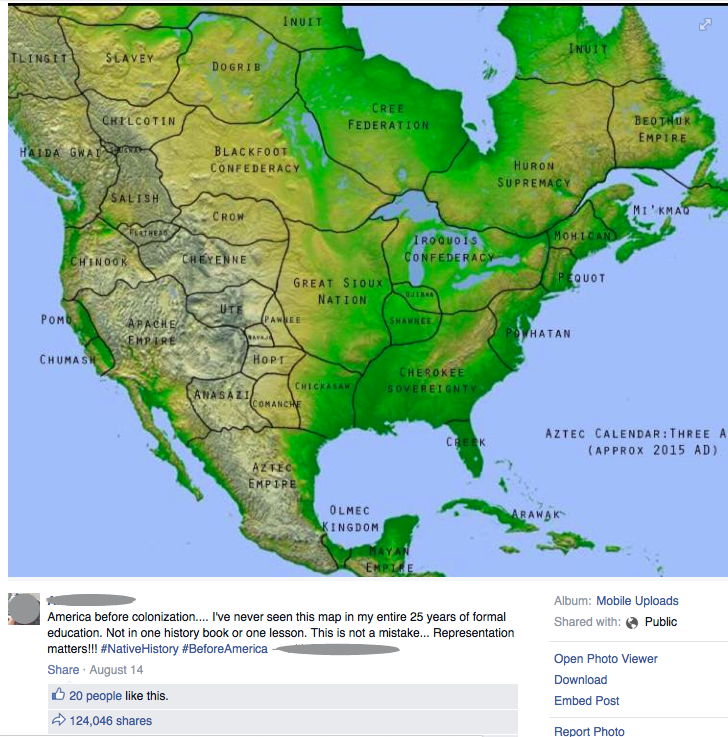
Yesterday, a cool-looking map showed up on my Facebook feed, shared by a friend; it depicts the North American continent with the historical political boundaries of the native Americans. It listed clear boundaries for separate states of the First Nations: Anasazi, Apache Empire, Arawak, Aztec Empire, Beothuk Empire, Cherokee Soverignty, Cheyenne, Chickasaw, Chilcotin, Chinook, Chumash, Comanche, Cree Federation, Creek, Crow, Dogrib, Flathead, Great Sioux Nation, Haida Gwai, Hopi, Huron Supremacy, Inuit, Iroquois Confederacy, Mayan Empire, Mi’kmaq, Mohican, Navajo, Ojibwa, Olmec Kingdom, Pawnee, Pequot, Pomo, Powhatan, Salish, Shuswap, Slavey, Tlingit, and Ute.
I’d never before seen such a clear depiction of the geopolitical boundaries of pre-Columbian America, and it was a stark reminder of how we, as a people, systematically invaded and destroyed a continent of cultured peoples. We wiped away their cultures, their languages, their history, and even the memory of them, leaving only scraps behind, and we protect our current borders of land they used to live on. The American Indian Wars ended in 1924, less than a hundred years ago, but it’s not even part of the American political dialog. And we’ve whitewashed our pogroms against Native Americans, in the same way we’re presently sugar-coating slavery in history courses.
The original person who posted the picture on Facebook also included this commentary,
America before colonization…. I’ve never seen this map in my entire 25 years of formal education. Not in one history book or one lesson. This is not a mistake… Representation matters!!! #NativeHistory #BeforeAmerica
Well said. And others agreed… the post has over 150,000 shares as I write this!
But something smelled wrong to me about the map itself.
